Land Use Planning
Current Projects
-
Ottawa County Groundwater
Over the last decade, Ottawa County residents and businesses have experienced issues related to groundwater, including reports of diminishing capacity and the presence of elevated levels of sodium chloride in some water wells.
In light of these issues, Michigan State University (MSU) was hired to conduct a comprehensive groundwater study for Ottawa County. This study confirmed the anecdotal reports: water levels in the deep bedrock aquifer system have been gradually declining over the last 20 years and, in certain areas of the County, sodium chloride levels in the bedrock aquifer are rising above recommended standards for drinking water and agricultural irrigation. Learn more »
- J.H. Campbell Generating Plant Closure
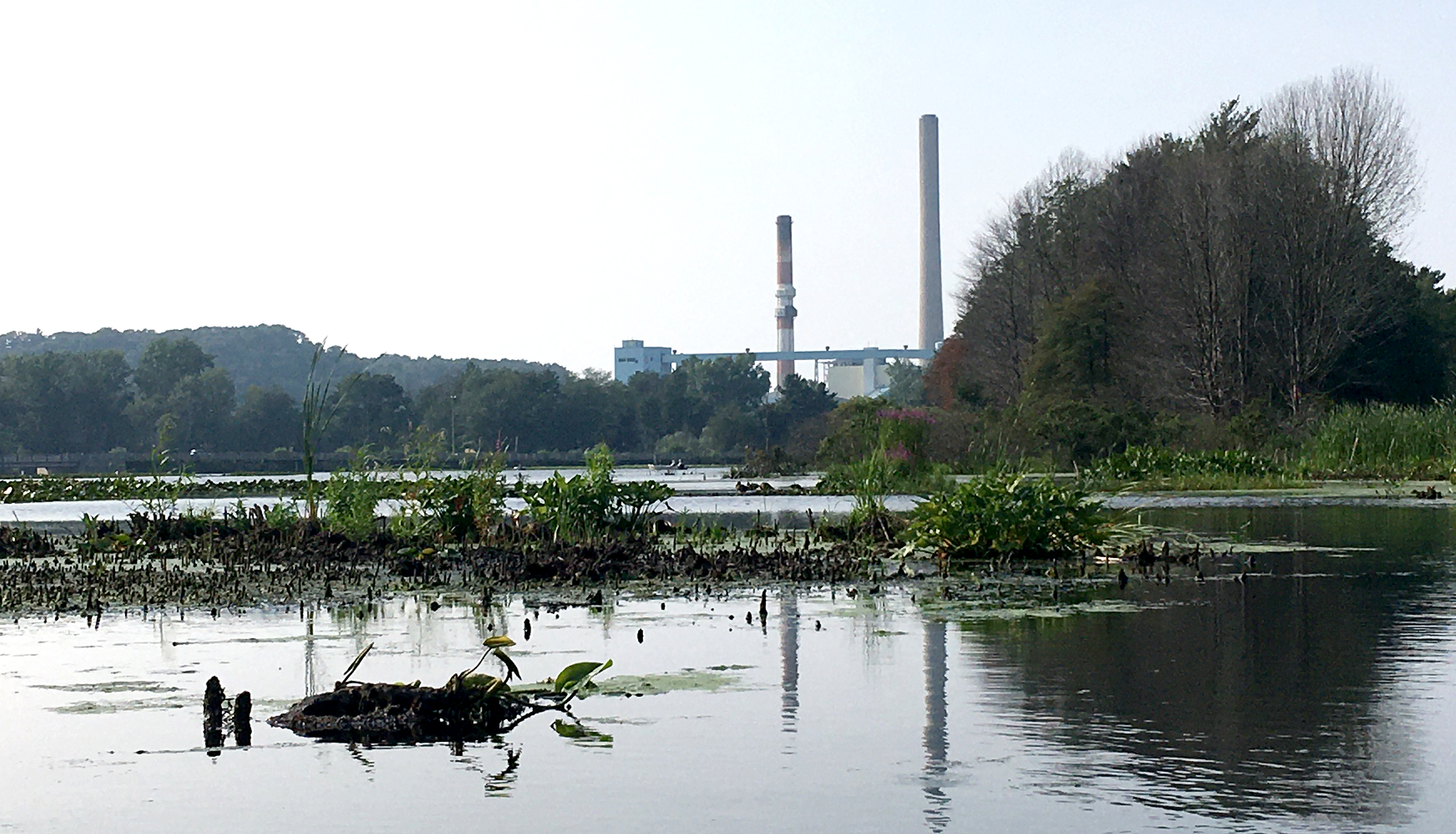
The J.H. Campbell Generating Plant as seen from the Pigeon River mouth in Port Sheldon Township in 2021.
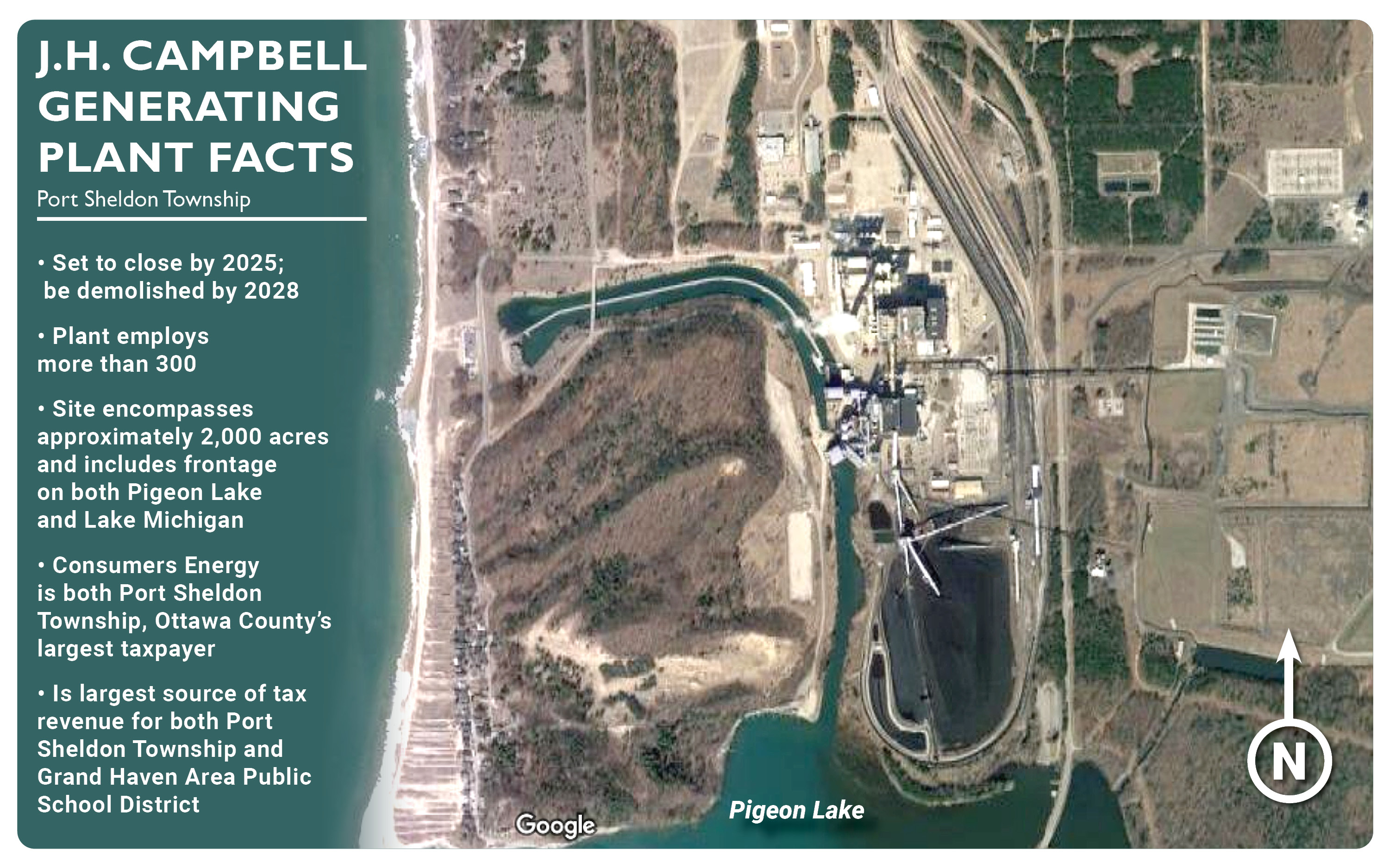
Consumers Energy announced on June 23, 2021, that it plans to decommission all of its coal-burning power plants by 2025, including the J.H. Campbell Generating Plant in Port Sheldon Township. For more than half a century, the J.H. Campbell complex has dominated the landscape of the Port Sheldon and Pigeon Creek area. Closure of this large electricity-generating station will mean major changes for Port Sheldon Township and Ottawa County as a whole.
Consider
- Consumers Energy's plant property holdings cover approximately 2,000 acres and include frontage on both Pigeon Lake and Lake Michigan
- The plant accounts for nearly 30% of Port Sheldon Township's tax base, and is the largest source of tax revenue for both Grand Haven Area Public Schools and Port Sheldon Township
- More than 300 people work at the plant
A Collaborative Process
The County had previously anticipated the eventual closure of the J.H. Campbell complex, and quickly put in motion plans to oversee the process and involve the public. To reverse and prevent any negative impacts the impending closure may have, the Ottawa County Board of Commissioners approved the creation of the J.H. Campbell Plant Closure Planning Committee. Representation on the Committee includes local units of government and community stakeholders, including: Port Sheldon Township; Ottawa County; Ottawa Area Intermediate School District; Grand Haven Public Schools; Grand Haven Chamber of Commerce; Ottawa County Parks & Recreation; and Lakeshore Advantage. Click here for a full list of Committee members. Charged with leading the effort internally and working closely with the Committee is the Department of Strategic Impact.
The Process & Community Engagement
The Committee, in collaboration with DSI staff and Consumers Energy, will conduct fact-finding and strategic planning to ensure the redevelopment of this highly visible and unique property benefits the community without sacrificing revenue for local units of government and school districts. The County and its partners will strive to keep residents and other community stakeholders updated as we engage further in this process.
First Steps
At this time, Consumers Energy is conducting in-depth environmental impact studies. Once these investigations are complete, the results will be shared with the County, enabling the Committee and DSI to determine what kind of redevelopment opportunities may exist.
April 28, 2023 Updates December 13, 2023 UpdatesMore Information
For more information on the Committee and the County's role in the plant closure, contact plan@miottawa.org or call 616.738.4852
- Non-motorized Pathway Plan
Ottawa County is home to many of West Michigan’s premiere recreational resources. Because of this, the Department has been working to highlight these assets and offer a unique experience to both residents and tourists by developing a series of pre-selected bike route maps for residents, tourists, and cyclists to showcase all of the great regional pathway and paved shoulder connections that exist in Ottawa County. These will include pre-selected restaurant and brewery tour maps, park tour maps, historical Ottawa tour maps, popular cycling route maps, festival tour maps, and many more. This information will eventually be available through a mobile-friendly website.
The Department also continues to seek opportunities to assist in expanding Ottawa County’s non-motorized network. The Department was able to successfully raise the funds to construct an extra foot of paved shoulders along Lakeshore Drive for the remaining 5 miles to complete the route within its entirety. By 2021, users will be able to safely and easily travel from Grand Haven to Holland by bicycle.
- Farmland Preservation
Ottawa County boasts 144,491 acres of land in farms and produces more than $726 million in agriculture products on those acres, according to the 2022 Census of Agriculture. The County’s long range land use planning is focused on preserving our productive farmland. Learn More »
- M-231 Bypass Project
The Michigan Department of Transportation’s multi-phase M-231 Bypass Project is designed to reduce traffic congestion and travel times while improving traffic flow and the movement of people and goods across the region.
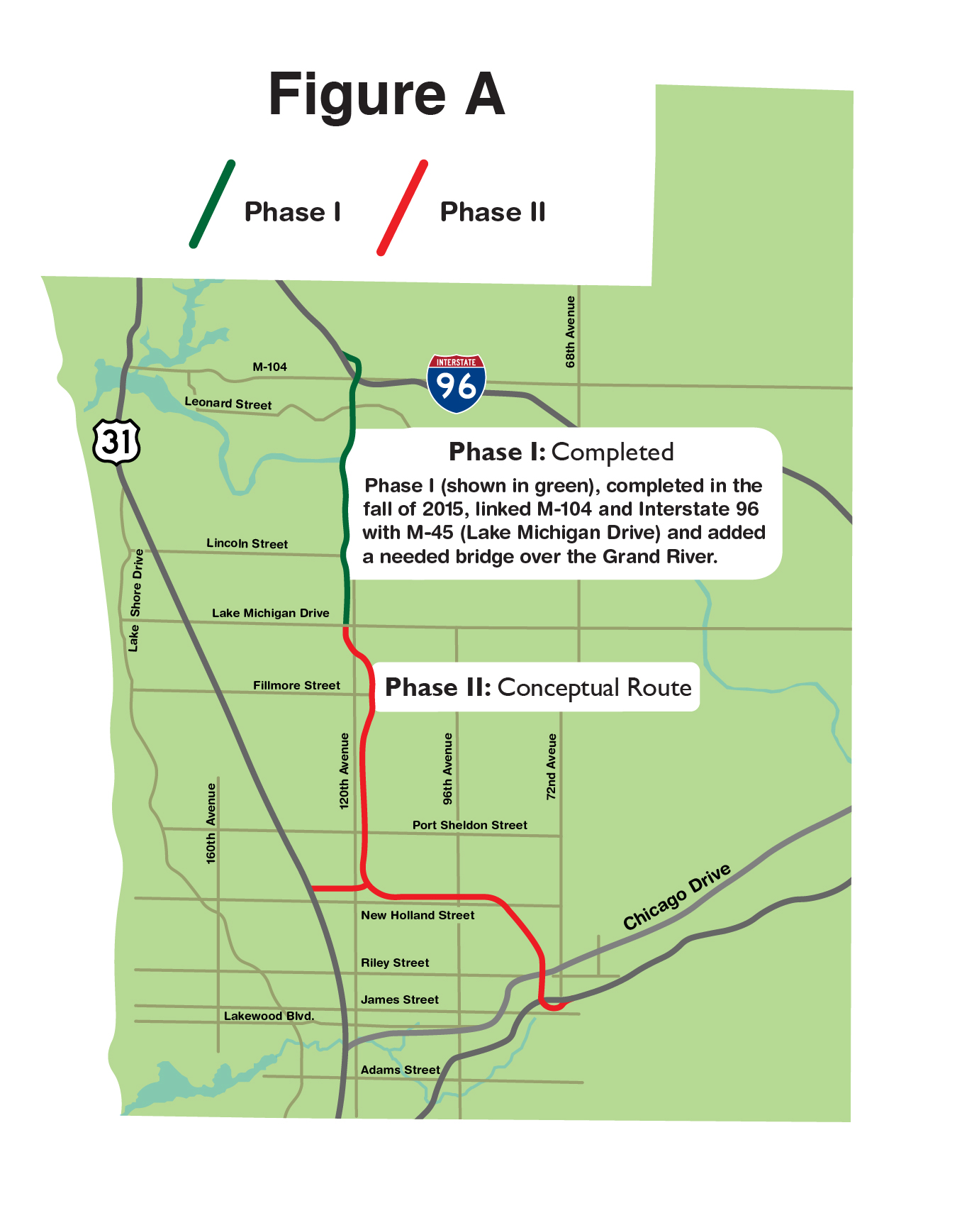
Phase I of M-231 linked M-104 and Interstate 96 with M-45 (Lake Michigan Drive) and added a much-needed bridge over the Grand River. The span, the seventh-longest in Michigan, also features the Sgt. Henry E. Plant Memorial Trail, a separated non-motorized pathway named after the local Civil War hero and Medal of Honor recipient.
Phase II of the MDOT project would link Lake Michigan Drive to U.S.-31, Chicago Drive, and M-196. Figure A, at left, based off of initial MDOT modeling, shows a proposed path the state highway may take in the future.
2020 Parcel Purchase
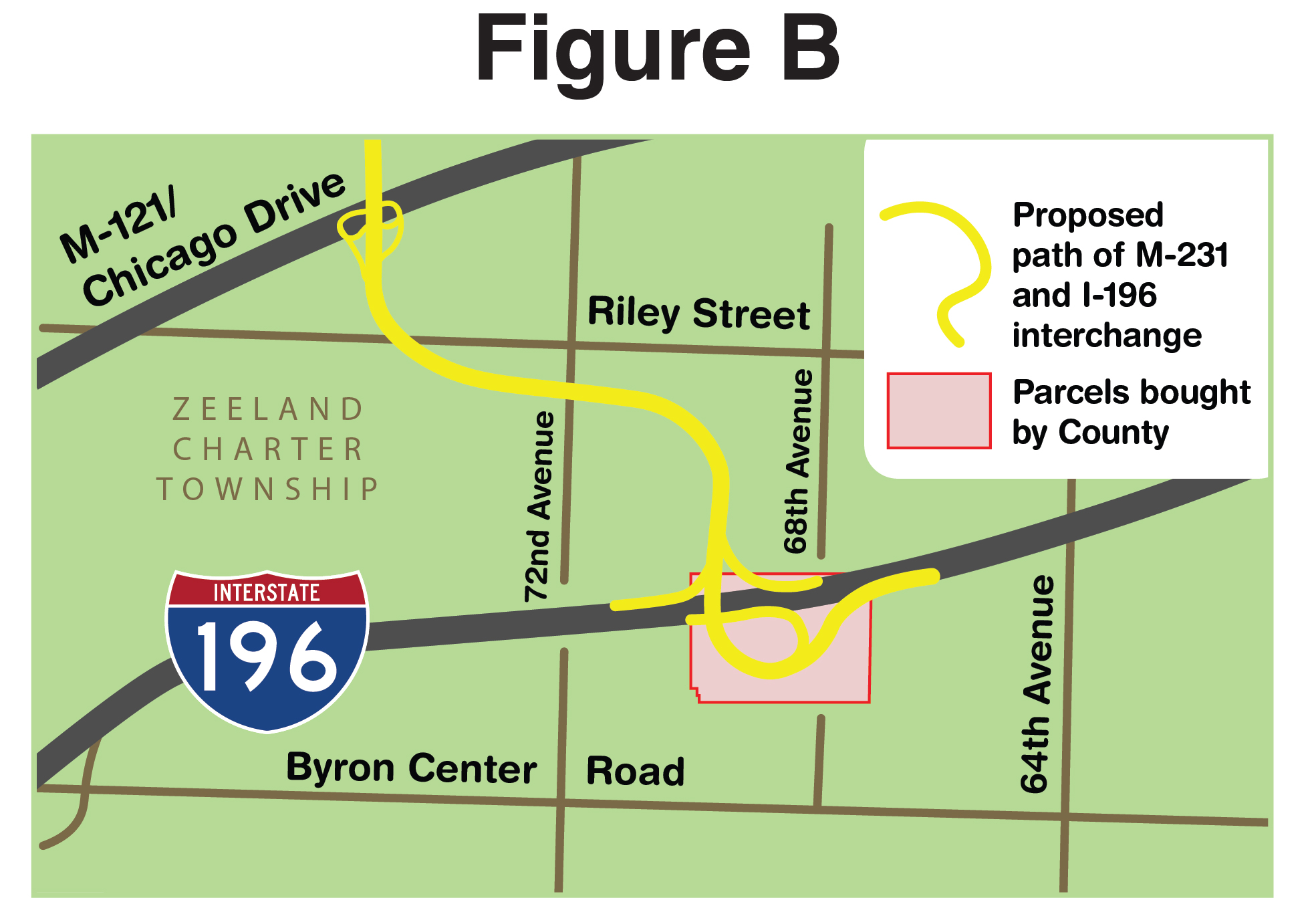
In an effort to reduce tax-payer burden in the event MDOT decides to move forward with Phase II, the Ottawa County Board of Commissioners acquired approximately 31 acres of vacant land along I-196 in Zeeland Charter Township to provide space for a future interchange. Figure B shows the purchased parcels and proposed location of this interchange. According to MDOT, this would be the ideal location for M-231 and I-196 to meet considering current development patterns.
Route Is Conceptual
At this time, all maps – including the ones shown on this page – of the potential route are based on conceptual modeling from MDOT. The maps do not reflect a final planned path for the route, but rather a rough estimate of the general direction of the route.
It is recommended all parties with land interests within the general area of the proposed route take the potential development of the highway into consideration.
MDOT has not informed Ottawa County of its intentions for the Phase II project, or of any potential timeline. Prior studies have identified several benefits to constructing Phase II, including improved traffic flow and reduced congestion in the greater Zeeland area. The Ottawa County Board of Commissioners, however, along with the Department of Strategic Impact, will always seek to serve the greater interest of the County and its residents.
In the event MDOT decides to move forward with the Phase II project, a great deal of additional planning and studies will need to be conducted, and numerous public meetings will be held to discuss the conceptual route options.
Contact Information
Residents, landowners and developers who have questions about plans for Phase II of M-231 are encouraged to contact MDOT here or call 517-241-2400.
- Urban Smart Growth Demonstration Project
The Urban Smart Growth Demonstration Project is designed to serve as a model for creating community planning documents that improve the ability of local leaders to plan for future growth and development. Multiple award-winning documents have been developed for the City of Hudsonville through the Project. Hudsonville was selected as the Project’s designated demonstration site after an extensive selection process among other interested communities across the County. The documents that have since been developed for Hudsonville include a highly-visual, graphics-based architectural design elements portfolio, a city-wide master plan, and a city-wide form-based zoning code (in process). As a result of participating in this Project, the City of Hudsonville has secured itself as one of Michigan’s premiere communities in terms of taking a proactive, innovative approach to enhancing its vibrancy, livability, and aesthetic character through effective community planning. Learn more about how the results of this Demonstration Project are positively impacting sustainable community design and planning HERE.
- West Michigan Pike
If you stop by the Department, you’ll likely notice a new artifact on display in our lobby—an early 20th century West Michigan Pike Marker. This stone marker is one of many that historically guided motorists along the West Michigan Pike, a series of roads and state parks, that stretched from Michigan City, Indiana, up to Mackinac City. Recovered behind an abandoned house adjacent to Spring Lake Country Club (SLCC), this marker, along with another identical one, have generously been donated to the County by the SLCC for historical purposes. While one will stay on display for public viewing in the office, plans for the other marker include displaying it at local historical venues or museums. Staff is currently working with local historians on developing a route similar to the West Michigan Pike that could be enjoyed by motorists and cyclists.
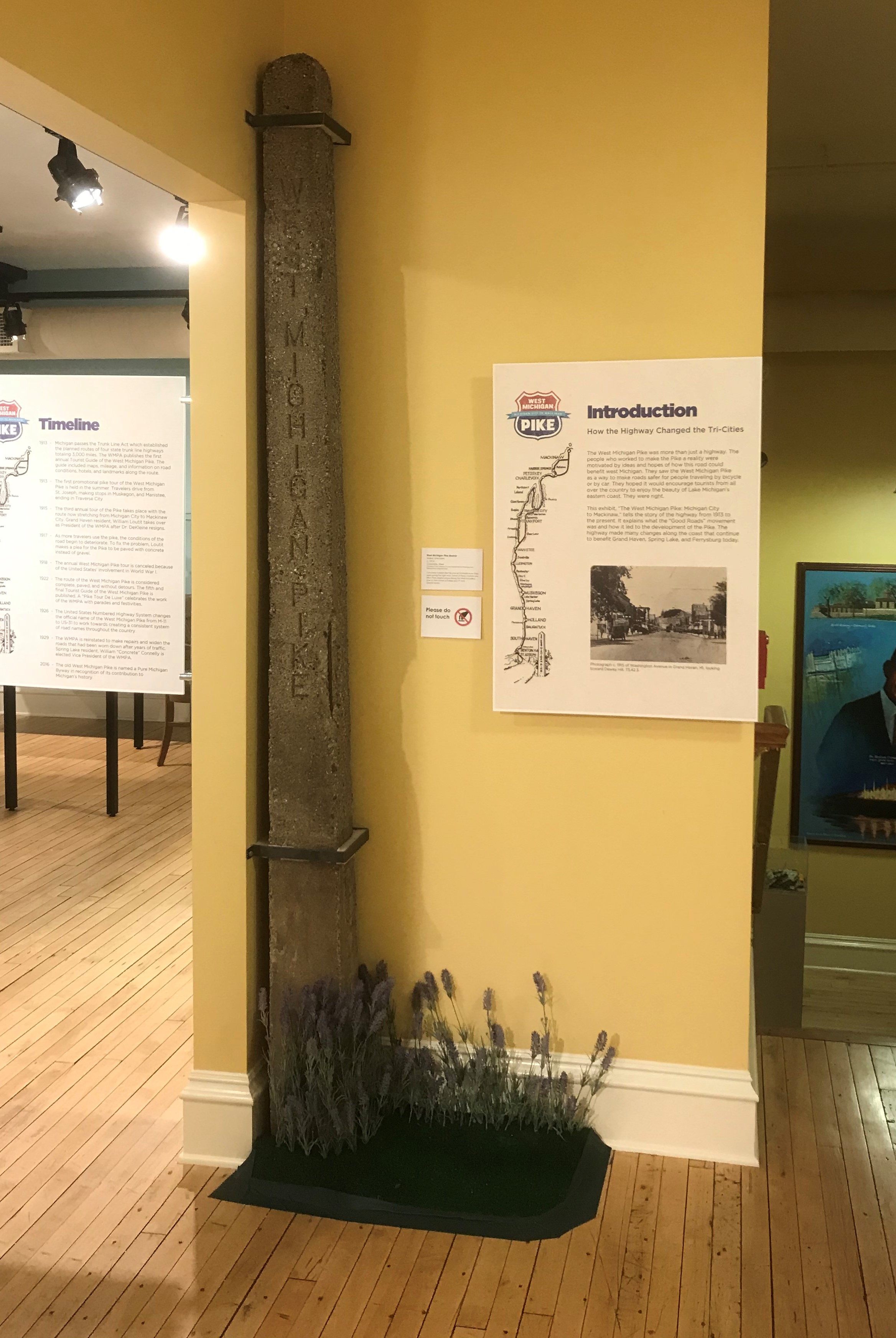
The Department loaned one of its Historic Pike Markers to the Tri-Cities Historical Museum in Grand Haven for an exhibit on the Pike. Concrete markers like this one let motorists know they were going the right way. Some of these markers are still in their original place along the WMP including one on the corner of Fulton and 7th St in Grand Haven.
- Remonumentation Program
As a result of Act 345 (State Survey and Remonumentation Act of 1990), Ottawa County is required to develop a program to re-establish and maintain the accuracy of all public land survey corners within the county. These land survey corners, or “monuments” form the basis on which public and private property descriptions are determined. After re-visiting and providing GPS coordinates for all 2,186 monuments within the county, Ottawa County is currently in the “maintenance” phase and will continue to complete this work throughout the life of this program.
- Standardized Mapping
The Ottawa County Department of Strategic Impact continues to work with local units of government throughout the County to encourage and facilitate the adoption of Standard Land Use District Titles and Colors for master plan and zoning maps.
Standardization will allow for easy viewing of commercial, retail, and industrial properties across the County on a single map, reducing the time and effort staff and consultants spend analyzing local zoning ordinances and master plans. It will also give citizens a better understanding of the location and type of land use districts in their community and in surrounding communities. Standardization does not change density, use, or any other local zoning ordinance and comprehensive land use plan requirements that have been adopted by local units of government. Learn More »
Completed Projects
- Lakeshore Drive Paved Shoulders (2021)
As one of Ottawa County’s premier scenic routes, Lakeshore Drive features high volumes of non-motorized traffic as runners, cyclists, and pedestrians access beaches and amenities between Holland and Grand Haven. Lakeshore Drive is designated as United States Bicycle Route (USBR) 35 and is a popular bicycle touring route within the region. While the route features an adjacent pathway offering protection from vehicular traffic, four-foot paved shoulders provide additional non-motorized capacity and give greater flexibility to non-motorized users.
Efforts to implement paved shoulders along Lakeshore Drive began in 2002 with the adoption of the Ottawa County Non-Motorized Pathway Plan. With the final segment completed in Summer 2021, four-foot paved shoulders now exist from Robbins Road near Grand Haven to 168th Avenue near Holland State Park. This will allow more users to enjoy the rich recreational opportunities along Ottawa County’s forested lakefront route.
- Spoonville Trail (2021)

The Spoonville Trail is an award-winning 4.2-mile non-motorized pathway that provides cyclists, runners, and walkers a safe and convenient access to northwest Ottawa County's abundance of recreational assets.
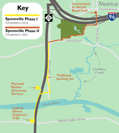
A cornerstone link in Ottawa County's non-motorized network, Spoonville connects the North Bank Trail running between Spring Lake and Nunica, and the 28-mile-long Idema Explorers Trail. Eventually, this span of trail will be part of a network linking the lakeshore with Grand Rapids.
The pathway traverses unique landscapes such as crossing the Grand River along the M-231 Bridge and winds through the forested ravines of the Terra Verde Golf Course - the first non-motorized pathway in Michigan to pass through a golf course.
Named after the 19th-century village that once existed on the north bank of the Grand River in Crockery Township, the trail also connects people to the region's rich history: A plaque commemorating Ottawa County's Civil War hero and Medal of Honor recipient Henry S. Plant lies on the M-231 Bridge. Additionally, MDOT plans to construct a Native American Education Terrace on the north side of the Grand River, highlighting the Anishinaabek people that inhabited the Grand River Valley centuries before European settlement.
Built on behalf of the Ottawa County Parks & Recreation Department, the Spoonvile Trail was built in two phases to properly utilize project funding sources. Phase I, which involved 1.75 miles of paved trail, encompassed a trailhead at North Cedar Drive in Robinson Township, along the M-231 bridge, ending at Leonard Road and 120th Avenue in Crockery Township. Phase II added 1.75 more miles of trail, from Leonard Road, through Terre Verde, and terminating on the north side of I-96 in Nunica, as well as a new 13-spot trailhead parking lot along 120th Avenue.
Construction of Spoonville Trail would not have been possible without funding from an array of generous donors. View a full list of donors here.
To learn more about Ottawa County's expanding network of trails, visit the Ottawa County's Parks' Recreation page.
- Ottawa County Metropolitan Planning Organizations Report (2020)
Transportation infrastructure - the highways we drive on, the buses we ride, and the ports and railways that carry freight to distant markets - are all influenced by metropolitan planning organizations (MPOs). These federally-mandated entities act as a bridge between the federal government and local municipalities, performing a “continuing, cooperative, and comprehensive” planning process in disbursing transportation funds within the region.
Ottawa County is the only county in Michigan that features three MPOs operating within its boundaries. This report highlights the Grand Valley Metropolitan Council (GVMC), the Macatawa Area Coordinating Council (MACC), and the West Michigan Shoreline Regional Development Commission (WMSRDC) and their roles in the local transportation ecosystem. As land use and transportation are inseparable, studying these MPOs provides a better understanding of transportation investments and how increased collaboration among local agencies can contribute to a higher quality of life in Ottawa County.
2020 Ottawa County Metropolitan Planning Organizations (MPO) Report »- West Michigan Transit Linkages Study (2012)
This Study was conducted to assess existing transportation services, determine the need for expanded regional commuter transportation services between major urban centers in Ottawa, Muskegon, and Kent Counties, and determine the feasibility of developing, implementing and operating a regional transportation network. Learn more by reviewing the reports:
- Musketawa Trail/Triick Farm Impasse Report and Recommendations (2011)
In 1991, the Michigan Department of Natural Resources (MDNR) purchased 24.5 miles of inactive railroad from the Central Michigan Railroad for recreational trail purposes. This includes a section of corridor east of 8th Avenue that runs adjacent to the Triick Family Farm. This particular railroad bed is a small section of an overall DNR plan to connect the Musketawa Trail in Ottawa County to the White Pine Trail in Kent County. Learn More »
- Tree Legacy Committee (2010)
The Tree Legacy Committee was created in 2006 in order to maintain and improve the aesthetic beauty of tree canopies along scenic roads in Ottawa County, such as Lakeshore Drive. After creating a proposed Tree Planting Policy, efforts were pursued to amend State legislation to limit any potential liability that a County Road Commission may have for trees planted in the Road Right-of Way, and to allow County Road Commissions to create special road designations (e.g. Legacy Roads) that accommodate closer tree plantings to enable tree-canopies to be established. The effort continues.
- Countywide Corridor Studies (2004)
The Ottawa County Countywide Corridor Plan was created in an effort to provide a framework from which to comprehensively plan for future traffic demand in the County and to preserve the aesthetic character of the County's overall roadway system. In order to accomplish the goals set forth in the Plan, it was decided that studies would be completed on each corridor to assess the need for future expansions, aesthetic preservation, and improved access management. The North-South Corridor Study and M-104 Corridor/Access Management Study have been completed.
- Road Salt Management (2004)
Winter application of road salts used to ensure motorist safety can contribute to elevated levels of sodium chloride in the glacial aquifer. Starting in the early 2000’s, the County began studying the impacts of road salt on the environment (with an emphasis on impacts to blueberry crops), and put into motion a mitigation plan. Since the plan went into action, the Ottawa County Road Commission has reduced road salt usage by as much as 30%. The County will continue to investigate the impacts of road salts, and consider additional options to lessen their effects. The mitigation plan earned a 2008 NACO Achievement Award. Learn More
- Model Ordinances
The Department has designed several Model Ordinances that can be utilized by local units of government in Ottawa County. These ordinances are provided below, with the Ottawa County Model Wind Energy Ordinance earning a 2009 NACo Achievement Award:
Contact the Department of Strategic Impact for more information about other projects completed prior to 2009.
- J.H. Campbell Generating Plant Closure


